Kozikhode Location
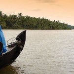
Kozhikode also known as calicut is located in the Malabar coast of Kerala. It is the third largest city of Kerala. The city has shoreline of 15 km and is surrounded by the Arabian sea in the west. Calicut is located about 410 km from the capital city Thiruvananthpuram of state Kerala. Many rivers flows from the city that originates from Sahyadri Mountains in the east about 60 km from Kozhikode.
Kozhikode on Google Map
How to Reach Kozhikode
Kozhikode is connected to rest of the major towns across Kerala and rest of India via road, rail, and air. The city has its own international airport and railway station with flights and trains operating on a frequent basis respectively. Also, the road network is pretty good with interstate and inter-district bus services and more.
By Air– Calicut International Airport is located in the city so its very easily accessed by air. Flights from various airlines like Kingfisher Airlines, Jet Airways, Indian Airlines from major cities flights on regular basis to the city. One can also reach here by Mumbai International Airport.
By Train– Kozikhode city has a railway station that is well connected by the railway networks of the state Kerala and other cities of India.
By Road– Kozhikode city has very good road network and is connected by other cities of India like Mangalore, Kochi, Thiruvananthapuram, Chennai, Bangalore, Coimbatore. There are various bus services from the cities like Mangalore, Kochi, Thiruvananthapuram, Chennai, Bangalore, Coimbatore to Kozhikode.
Kozhikode Distance Time Chart
| City | Location |
|---|---|
| Coimbatore | 187 Km |
| Mysore | 209 Km |
| Bangalore | 355 Km |
| Mangalore | 233 Km |
| Goa | 583 Km |
| Mumbai | 1248 Km |
| Chennai | 684 Km |
| Kottayam | 250 km |
| Kollam | 336 Km |
| Madurai | 368 Km |
| Thiruvanathpuram | 404 Km |
| Cochin | 203 Km |


Add How to Reach Kozhikode Feedback, Comments, Reviews