Idukki means a place with a deep gorge. River Periyar flowed through a canyon between two rocky mountains. Kurava and Kurathy. The legend told from generation of the ancient Adivasi Muthuvan tribe here is that Sita, during her forest sojourn with Rama, bathed in the canyon, and on seeing an Adivasi couple – Kuravan and Kurathy watching her naked beauty, she cursed them into two rocky mountains.Agriculture is the main occupation of the people in the District. Dairy is the main supplementary source of income of the farmers in the district.The economy of Idukki is predominantly agricultural, Cardamom, tea, tapioca, rice, pepper, rubber, coconut, sugarcane, coffee, are canut, ginger, lemon grass and vegetables are the most important agricultural produces of the district.About 66% of the State’s Power needs come from the Hydroelectric Power Projects in Idukki.This beautiful High range district of Kerala is geographically known for its mountainous hills and dense forests.
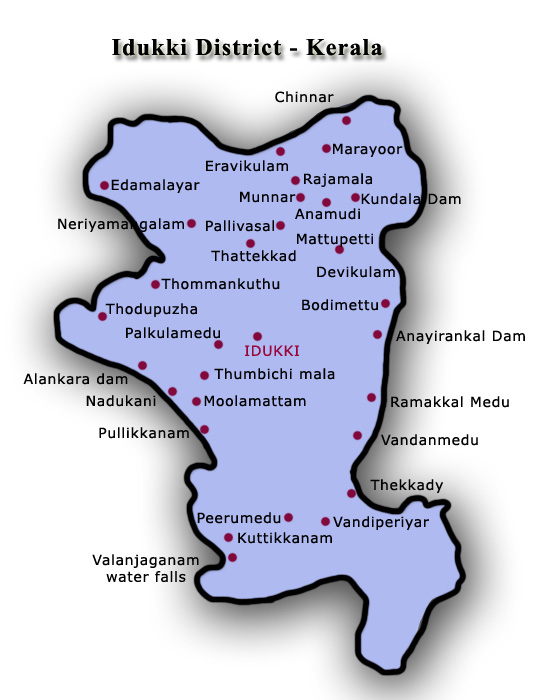
Idukki Tourist Map
Idukki Districts Facts
| Headquarter | Painavu |
| Population | 11,07,453 |
| Area | 5,105.22 Square Kilometers |
| Literacy | 92.20% |
| Sex Ratio | 1,006 Female per 1000Male |
| Official Language | Malayalama, English |
| Official Website | http://www.ekm.kerala.gov.in/ |
| Density | 254/Sq.Km |
| Taluks | Devikulam, Udumpanchola, Peerumade, Thodupuzha. |
Brief History of Idukki
The district was formed on January 26, 1972 carving out of Devikulam, Peerumedu and Udumbanchola taluks from Kottayam district and Thodupuzha taluk from Ernakulam district. It extends by 115 kms. from south to north and 67 kms. From east to west. Historians believes that for some time these regions were under the region of the Thekkumkoor Kingdom. It was proved that Vennimala, one of the capitals of the Thekkumkoor Rajas, was in Idukki district. Poonjar Kingdom was established by Manavikrama Kulasekhara Perumal. Manavikraman brought Meenachil taluk and the High Range under his rule from the Thekkumkoor Raja. Thus major portions of Idukki district came under the rule of the Poonjar Raja.
Idukki Geography and Climate
Idukki is the second largest district of Kerala State of India.Rugged mountains and forests cover about 97 percent of the total area of the District.The district borders the Kerala districts of Pathanamthitta to the south, Kottayam to the southwest, Ernakulam to the northwest and Thrissur to the north and Coimbature, Dindigul and Theni Districts in Tamilnadu to the east. Some of the important river of the district are The Periyar, Thodupuzhayar and Thalayar. There is a huge diversity of Flora and Fauna in the district as it is mainly covered with the forest area. Periyar Tiger Reserve in the south, Kurinjimala Sanctuary to the east, Chinnar Wildlife Sanctuary to the northeast, Eravikulam National Park and Anamudi Shola National Park to the north, Pampadum Shola National Park to the south and Thattekad Bird Sanctuary in the west.
Idukki District have a variable climate.The western parts of the district comprising midland area experiences moderate climate, temperature varying between 21degree C to 27degreeC with minimum seasonal variation. The eastern parts of the district located in the highland have a comparatively cold climate with temperature varying between minus 1 degree C to 15 degree C in November/January and 5 degree C to 15 degree C during March/April.
List of Places to visit in Idukki
A landlocked district, Idukki is one of the most nature rich areas of Kerala. High ranges and wooded valleys are girded by three main rivers – Periyar, Thalayar and Thodupuzhayar – and their tributaries.The River Pamba also has its origin here.Idukki offers diverse attractions like Wildlife sancturies, Hill stations, Dams, Specie plantation tours, Mountain treks, Elephant rides etc. Some of the famous places are-
- Munnar
- Peermede
- Thekkedy
- Pothamadu
- Devikulam
- Pallivasal
- Attukal
- Nyayamakad
- Chithirapuram
- Mattupetty
- Lock Heart Gap
- Rajamala
- Echo Point
- Eravikulam National Park
- Power House waterfalls
- Kundala
- Anayiranka
- Top station
- Marayoor
- Cheeyappara and Valara waterfalls
- Chinnar wild life sanctuary
- Idukki Arch Dam
- Idukki Wildlife Sanctuary
- Hill View Park
- Nadukani
- Kalliyanathandu
- Malankara Reservoir
- Thommankuthu
- Keezharkuthu
- Kalvarimount
- Vandiperiyar
- Thrissanku Hills
- Peeru Hills
- Grampi
- Sahyadri Ayurvedic Centre
- The Periyar Wildlife Sanctuary
- Kurisumala
- Kumily
- Murikkady
- Pandikuzhi
- Chellarkovil
- Vandiperiyar
- Ramakalmedu
Transportation in Idukki
Road– Road transport is the only mode of transportation in Idukki – both for moving goods and passengers. The total extend of road lines in the district is about 8000 Kms. National Highway NH-49 passes through the district. Few state highways also passes through the District .KSRTC has 5 operating units in the district Viz, Kattappana, Kumily, Moolamattam, Munnar and Thodupuzha.
Railways– Idukki District has no rail routes as the District is mainly covered with mountains here. Some of the nearby railway station from here are Kottayam about 114 km, Theni about 60km and Changanassery about 95 km are the nearest railway stations to the City.
Airways–Cochin International Airport is the nearest airport to the district about 190 km from City center.
